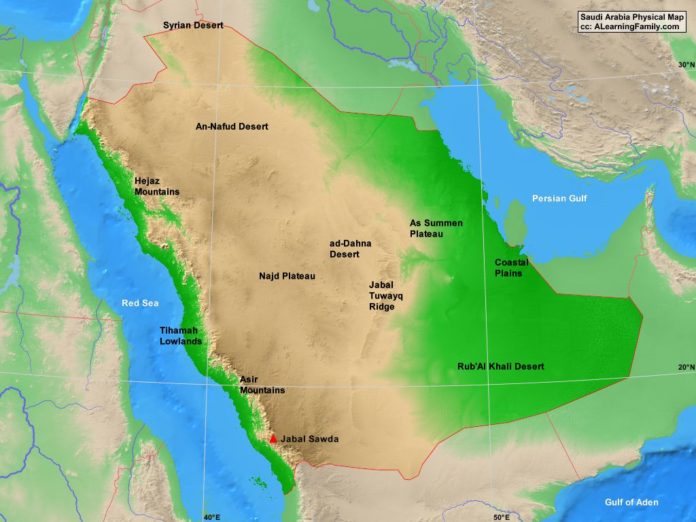
The Saudi Arabia physical map is provided. The physical map includes a list of major landforms and bodies of water of Saudi Arabia.
A student may use the blank Saudi Arabia outline map to practice locating these physical features.
Features of the Saudi Arabia Physical Map
Neighboring Countries
- Bahrain
- Egypt
- Eritrea
- Iraq
- Iran
- Israel
- Jordan
- Kuwait
- Oman
- Qatar
- Sudan
- United Arab Emirates
- Yemen
Major Cities
- Riyadh(capital)
- Abu Aris
- ad-Dammam
- ad-Dawadimi
- Afif
- al-Bahah
- al-Hafji
- al-Harj
- al-Hawiyah
- al-Hufuf
- al-Jubayl
- al-Madinah
- al-Qarayyah
- at-Rass
- at-Ta’if
- Ara’ar
- az-Aulfi
- Bisah
- Buraydah
- Dariyah
- Hafar-al-Batin
- Hamis Musayt
- Jiddah
- Mecca
- Rafhah
- Sakakah
- Sarurah
- Tabuk
- Turayf
- Umm Lajj
- Yanbu
Bodies of Water
- Gulf of Aden
- Persian Gulf
- Red Sea
Major Landforms
- ad-Dahna Desert
- An-Nafud Desert
- Asir Mountains
- Coastal Plains
- Hejaz Mountains
- Jabal Sawda
- Jabal Tuwayq Ridge
- Najd Plateau
- Rub’Al-Khali Desert
- Syrian Desert
- Tihamah Lowlands

