Saturday, April 27, 2024
Home Blog Page 26

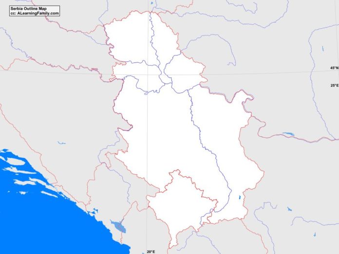
Serbia Outline Map

Serbia outline map
A blank outline map of Serbia (Creative Commons: A Learning Family).

The Serbia outline map is provided. The outline map includes a list of neighboring countries, major cities, major landforms and bodies of water of Serbia.

A student may use the blank map to practice locating these political and physical features.

Features of the Serbia Outline Map

Neighboring Countries

  • Albania
  • Bosnia and Herzegovina
  • Bulgaria
  • Croatia
  • Hungary
  • Macedonia
  • Montenegro
  • Romania

Major Cities

  • Belgrade (capital)
  • Backa Palanka
  • Bor
  • Cacak
  • Dakovica
  • Gnjilane
  • Indija
  • Jagodina
  • Kikinda
  • Kosovska Mitrovica
  • Kragujevac
  • Kraljevo
  • Krusevac
  • Leskovac
  • Nis
  • Novi Pazar
  • Novi Sad
  • Paracin
  • Pec
  • Pirot
  • Pristina
  • Prizren
  • Pozarevac
  • Prokuplje
  • Sabac
  • Smederevo
  • Smederevska Palanka
  • Subotica
  • Urosevac
  • Uzice
  • Valjevo
  • Vranje
  • Vrbas
  • Vrsac
  • Zajecar
  • Zrenjanin

Major Landforms

  • Balkan Mountains
  • Danube River
  • Dinaric Alps
  • Golija Mountains
  • Kopaonik Mountains
  • Midzor
  • Morava River
  • Pannonian Plain
  • Rhodopes Mountains
  • Sava River
  • Serbian Carpathians
  • Tisza River
  • Zlatibor Mountains

Bibliography

  • Serbia Political Map
  • Serbia Physical Map
  • Serbia

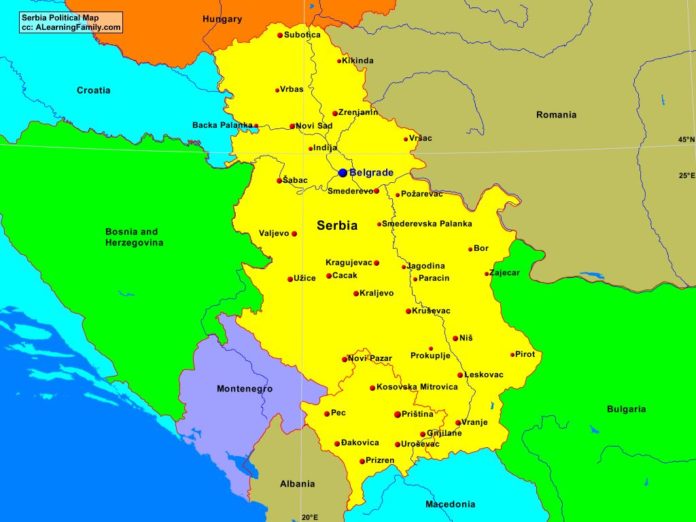
Serbia Political Map

Serbia political map
A political map of Serbia (Creative Commons: A Learning Family).

The Serbia political map is provided. The political map includes a list of neighboring countries and major cities of Serbia.

A student may use the blank Serbia outline map to practice locating these political features.

Features of the Serbia Political Map

Neighboring Countries

  • Albania
  • Bosnia and Herzegovina
  • Bulgaria
  • Croatia
  • Hungary
  • Macedonia
  • Montenegro
  • Romania

Major Cities

  • Belgrade (capital)
  • Backa Palanka
  • Bor
  • Cacak
  • Dakovica
  • Gnjilane
  • Indija
  • Jagodina
  • Kikinda
  • Kosovska Mitrovica
  • Kragujevac
  • Kraljevo
  • Krusevac
  • Leskovac
  • Nis
  • Novi Pazar
  • Novi Sad
  • Paracin
  • Pec
  • Pirot
  • Pristina
  • Prizren
  • Pozarevac
  • Prokuplje
  • Sabac
  • Smederevo
  • Smederevska Palanka
  • Subotica
  • Urosevac
  • Uzice
  • Valjevo
  • Vranje
  • Vrbas
  • Vrsac
  • Zajecar
  • Zrenjanin

Bibliography

  • Serbia Political Map
  • Serbia Physical Map
  • Serbia

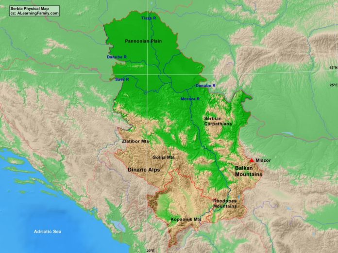
Serbia Physical Map

Serbia physical map
A physical map of Portugal (Creative Commons: A Learning Family).

The Serbia physical map is provided. The physical map includes a list of major landforms and bodies of water of Serbia.

A student may use the blank Serbia outline map to practice locating these physical features.

Features of the Serbia Physical Map

Major Landforms

  • Balkan Mountains
  • Danube River
  • Dinaric Alps
  • Golija Mountains
  • Kopaonik Mountains
  • Midzor
  • Morava River
  • Pannonian Plain
  • Rhodopes Mountains
  • Sava River
  • Serbian Carpathians
  • Tisza River
  • Zlatibor Mountains

Bibliography

  • Serbia Political Map
  • Serbia Physical Map
  • Serbia

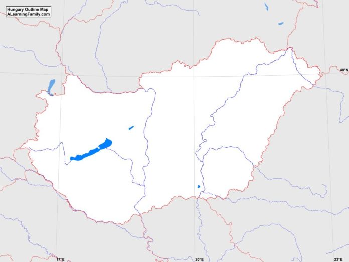
Hungary Outline Map

Hungary outline map
A blank outline map of Hungary (Creative Commons: A Learning Family).

The Hungary outline map is provided. The outline map includes a list of neighboring countries, major cities, major landforms and bodies of water of Hungary.

A student may use the blank map to practice locating these political and physical features. Click on the map for a full-sized image of the map.

Features of the Hungary Outline Map

Neighboring Countries

  • Austria
  • Croatia
  • Romania
  • Serbia
  • Slovakia
  • Slovenia
  • Ukraine

Major Cities

  • Budapest (capital)
  • Bekescaba
  • Debrecen
  • Dunaujvaros
  • Eger
  • Erd
  • Gyor
  • Kaposvar
  • Kecskemet
  • Miskolc
  • Nagykaniszsa
  • Nyiregyhaza
  • Pecs
  • Sopron
  • Szeged
  • Szolnok
  • Szombathely
  • Tatabanya
  • Veszprem
  • Zalaegerszeg

Major Landforms

  • Bakony Mountains
  • Bukk Mountains
  • Danube River
  • Drava River
  • Great Hungarian Plain
  • Kekes
  • Lake Balaton
  • Little Hungarian Plain
  • Matra Mountains
  • Mecsek Mountains
  • North Hungarian Mountains
  • Tisza River
  • Transdanubian Mountains

Bibliography

Hungary Political Map

Hungary political map
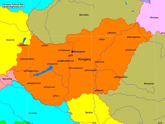
A political map of Hungary (Creative Commons: A Learning Family).

The Hungary political map is provided. The political map includes a list of neighboring countries and major cities of Hungary.

A student may use the blank Hungary outline map to practice locating these political features.

Features of the Hungary Political Map

Neighboring Countries

  • Austria
  • Croatia
  • Romania
  • Serbia
  • Slovakia
  • Slovenia
  • Ukraine

Major Cities

  • Budapest (capital)
  • Bekescaba
  • Debrecen
  • Dunaujvaros
  • Eger
  • Erd
  • Gyor
  • Kaposvar
  • Kecskemet
  • Miskolc
  • Nagykaniszsa
  • Nyiregyhaza
  • Pecs
  • Sopron
  • Szeged
  • Szolnok
  • Szombathely
  • Tatabanya
  • Veszprem
  • Zalaegerszeg

Bibliography

Hungary Physical Map

Hungary physical map
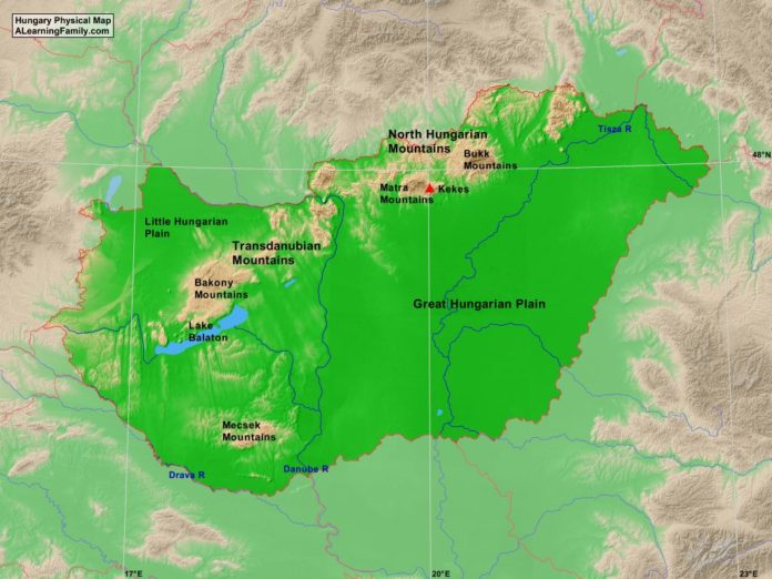
A physical map of Hungary (Creative Commons: A Learning Family).

The Hungary physical map is provided. The physical map includes a list of major landforms and bodies of water of Hungary.

A student may use the blank Hungary outline map to practice locating these physical features.

Features of the Hungary Physical Map

Major Landforms

  • Bakony Mountains
  • Bukk Mountains
  • Danube River
  • Drava River
  • Great Hungarian Plain
  • Kekes
  • Lake Balaton
  • Little Hungarian Plain
  • Matra Mountains
  • Mecsek Mountains
  • North Hungarian Mountains
  • Tisza River
  • Transdanubian Mountains

Bibliography

Slovenia Outline Map

Slovenia outline map
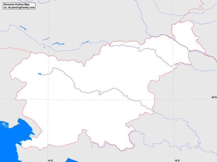
A blank outline map of Slovenia (Creative Commons: A Learning Family).

The Slovenia outline map is provided. The outline map includes a list of neighboring countries, major cities, major landforms and bodies of water of Slovenia.

A student may use the blank map to practice locating these political and physical features.

Features of the Slovenia Outline Map

Neighboring Countries

  • Austria
  • Croatia
  • Hungary
  • Italy

Major Cities

  • Ljubljana (capital)
  • Ajdovscina
  • Bistrica
  • Bled
  • Brezice
  • Celje
  • Crnomelj
  • Domzale
  • Grosuplje
  • Idrija
  • Izola
  • Jesenice
  • Kamnik
  • Kocevje
  • Koper
  • Kranj
  • Krsko
  • Litija
  • Logatec
  • Lucija
  • Maribor
  • Murska Sobota
  • Nova Gorica
  • Novo Mesto
  • Postojna
  • Ptuj
  • Ravne
  • Skofja Loka
  • Slovenj Gradec
  • Slovenska Bistrica
  • Velenje
  • Vrhnika

Bodies of Water

  • Gulf of Trieste

Major Landforms

  • Brkini Mountains
  • Dinarides
  • Drava River
  • Julian Alps
  • Karavanke Range
  • Koeevski Rog
  • Mura River
  • Nanos Mountains
  • Pannonian Basin
  • Pohorje Mountains
  • Sava Hills
  • Sava River
  • Savinja Alps
  • Slovene Hills
  • Triglav
  • Zumberak Mountains

Bibliography

Slovenia Political Map

Slovenia political map
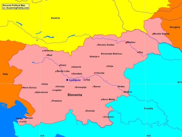
A political map of Slovenia (Creative Commons: A Learning Family).

The Slovenia political map is provided. The political map includes a list of neighboring countries and major cities of Slovenia.

A student may use the blank Slovenia outline map to practice locating these political features.

Features of the Slovenia Political Map

Neighboring Countries

  • Austria
  • Croatia
  • Hungary
  • Italy

Major Cities

  • Ljubljana (capital)
  • Ajdovscina
  • Bistrica
  • Bled
  • Brezice
  • Celje
  • Crnomelj
  • Domzale
  • Grosuplje
  • Idrija
  • Izola
  • Jesenice
  • Kamnik
  • Kocevje
  • Koper
  • Kranj
  • Krsko
  • Litija
  • Logatec
  • Lucija
  • Maribor
  • Murska Sobota
  • Nova Gorica
  • Novo Mesto
  • Postojna
  • Ptuj
  • Ravne
  • Skofja Loka
  • Slovenj Gradec
  • Slovenska Bistrica
  • Velenje
  • Vrhnika

Bibliography

Slovenia Physical Map

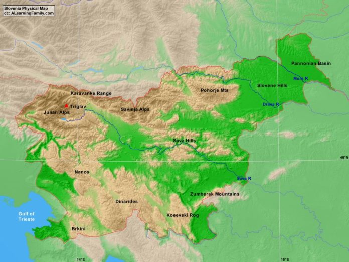
Slovenia physical map
A physical map of Slovenia (Creative Commons: A Learning Family).

The Slovenia physical map is provided. The physical map includes a list of major landforms and bodies of water of Slovenia.

A student may use the blank Slovenia outline map to practice locating these physical features.

Features of the Slovenia Physical Map

Bodies of Water

  • Gulf of Trieste

Major Landforms

  • Brkini Mountains
  • Dinarides
  • Drava River
  • Julian Alps
  • Karavanke Range
  • Koeevski Rog
  • Mura River
  • Nanos Mountains
  • Pannonian Basin
  • Pohorje Mountains
  • Sava Hills
  • Sava River
  • Savinja Alps
  • Slovene Hills
  • Triglav
  • Zumberak Mountains

Bibliography

Moldova Outline Map

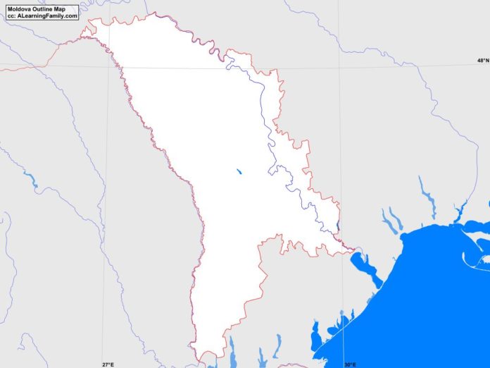
Moldova outline map
A blank outline map of Moldova (Creative Commons: A Learning Family).

The Moldova outline map is provided. The outline map includes a list of neighboring countries, major cities, major landforms and bodies of water of Moldova.

A student may use the blank map to practice locating these political and physical features. Click on the map for a full-sized image of the map.

Features of the Moldova Outline Map

Neighboring Countries

  • Romania
  • Ukraine

Major Cities

  • Chisinau (capital)
  • Balti
  • Briceni
  • Cahul
  • Calarasi
  • Camenca
  • Causeni
  • Cimislia
  • Cladir Lunga
  • Comrat
  • Dnestrovsc
  • Drochia
  • Dubasari
  • Edinet
  • Falesti
  • Floresti
  • Glodeni
  • Hincesti
  • Ialoveni
  • Leova
  • Nisporeni
  • Ocnita
  • Orhei
  • Ribnita
  • Riscani
  • Singerei
  • Slobozia
  • Soroca
  • Straseni
  • Taraclia
  • Tiraspol
  • Ungheni
  • Vulcanesti

Bodies of Water

  • Black Sea

Major Landforms

  • Balanest Hill
  • Balti Steppe
  • Bugeac Plain
  • Carpathian Mountains
  • Dneister Hills
  • Dneister River
  • Moldavian Plain
  • Moldavian Plateau
  • Prut River

Bibliography

Featured Posts